Col du Galibier - France
The Col du Galibier is probably the most famous mountain pass in road cycling. Since 1911, the pass has frequently been included in the Tour de France and countless battles have been fought on its slopes. If you climb only one pass during your cycling days, this is the one.
The Col du Galibier is most commonly climbed from the north via the long approach from Saint-Michel-de-Maurienne, which includes the Col du Télégraphe. This is a demanding 36 km ascent with 2,110 m of elevation gain. Alternatively, riders can start from Valloire, the last village before the core of the climb.
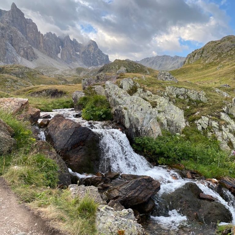
The Col du Galibier is hidden behind a pass on both approaches, which adds to its sense of isolation. The landscape becomes stark and almost lunar, dominated by the Grand Galibier at 3,228 m and its surrounding peaks.
Access from the south is somewhat easier, via a busy valley linking Briançon and Bourg-d’Oisans. This route culminates at the Col du Lautaret, which lies just 600 m below the Col du Galibier, providing a long but effective warm-up before turning off the main road for the final push to the summit.
It is the beauty, remoteness, and wild, unpredictable nature of this area that set the Col du Galibier apart from other high Alpine passes.
Col du Galibier – 2,642 m
Northern ascent from Valloire
If a full ascent feels too demanding in one go, the climb can be broken up by starting in Valloire and perhaps riding the Col du Télégraphe on another day. Beginning in Valloire makes the ride more manageable, and starting higher up also allows you to tackle the climb early in the morning, when the road is quieter and the air is cooler.
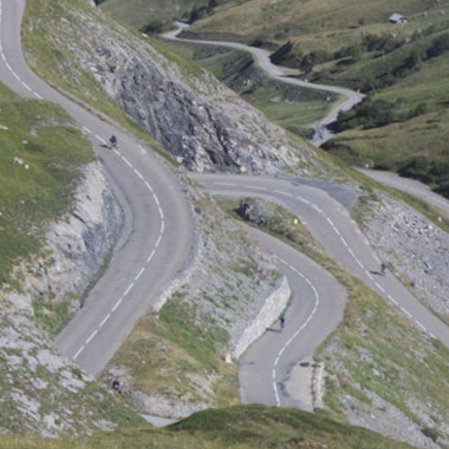
From Valloire, the road forms the heart of the Galibier ascent: 17.5 km long, with 1,213 m of elevation gain. There are only 14 switchbacks, and the road climbs relentlessly along long, straight sections, cutting deep into the mountain and leading to a place that feels remote and unique.
As with all major climbs, it can be divided into distinct sections.
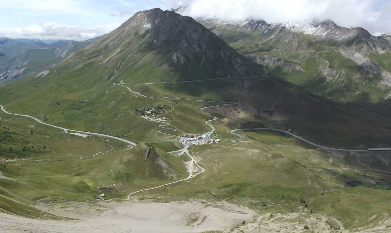
Deep into the valley to 2000m altitude
Valloire is a charming village and ski resort set in the aptly named Valloire Valley at an altitude of 1,430 m. The road climbs gently through the town and, once the last hotels and ski lifts of Les Verneys are left behind, continues straight along the valley floor. After 10.5 km and around 600 m of elevation gain, it reaches the head of the valley at Plan-Lachat at approximately 2,000 m altitude.
Along the way, the route passes an altiport and crosses the La Valloirette stream from right to left. As you progress deeper into the valley, the road hugs the base of the Roche Olvera mountain on the right. When the mountain finally recedes, the road turns sharply to the right and climbs the hillside, marking the beginning of a new section of the ascent.
Short vertical up through lovely switchbacks
Switchback sections are rare on this climb, making this short stretch—around 2.3 km in length with approximately 170 m of elevation gain—a notable exception. Here, the road rises through five switchbacks high above the Valloire Valley, leading toward an almost delta-like expanse at the foot of the Grand Galibier, which towers at 3,228 m over the landscape to the left.
This is a particularly beautiful section of the ride, marking the transition from a lower valley to a high-altitude plateau. While the valley below remains green and dotted with occasional trees and shrubs, the base of the Galibier massif becomes stark and rocky, with sheer cliffs above and a colour palette that shifts decisively to shades of brown.
Deep into the mountain and to the top at 2642m
The final 5.5 km, gaining 470 m in elevation, pass through a stark, almost lunar landscape. Rock and cliff dominate the scenery, making you feel small as you ride along this narrow strip of tarmac, as though you could be swallowed by the elements at any moment. These are the moments that remind me why I ride my bike.
High above the road to the left rises the Grand Galibier, its rocky ridge stretching northwards. The route first runs straight towards the Granges du Galibier, a small human outpost with a mountain inn, before sweeping into a long right-hand curve towards the road tunnel. From the tunnel to the summit lies the second and final series of switchbacks, with gradients reaching up to 12%.
Reaching the summit of the pass is a truly unique experience—nothing quite compares to the Galibier.
Col du Telegraphe - 1567m
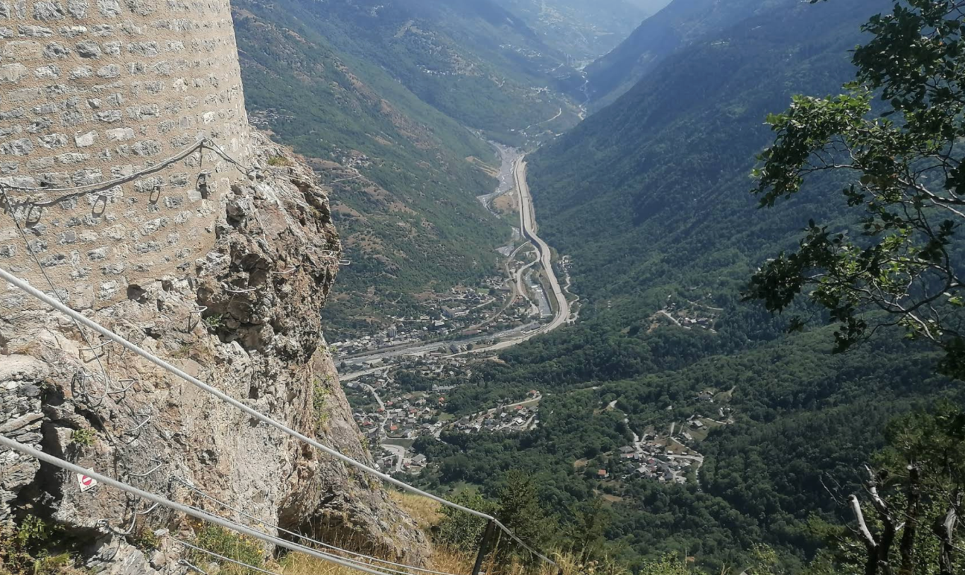
Before the climb to the Galibier can start in ernest, the Col du Telegraphe has to be negotiated. The road leads from St Michele de Maurienne to Valloire past the Fort du Telegraphe which sits high above the Maurienne valley, having guarded this strategic passage through the Alps for centuries past.
I have to be honest: without the Galibier at its back, the Col du Télégraphe would otherwise go largely unnoticed even though the climb is not without its charms. However, because the Télégraphe serves as the access climb to the Galibier, it has been ridden extensively by amateurs, enthusiasts, and the Tour de France itself. At the time of writing, it has featured 31 times in the Tour—quite an achievement.
From a rider’s perspective, the pass is 12 km long and climbs 850 m, which in itself makes for a demanding effort, with gradients persistently between 7% and 10%. The Fort du Telegraphe is visible from a long way down the valley and towers over the climb, dramatically perched on the outermost cliff above. The climb then dives into a forested section and eats its way deep into the hillside and upwards at a constant gradient, past the turnoff to Valmeinier. The road is twisty and almost entirely enclosed by forest, with only occasional clearings offering glimpses of the view. It truly comes to life in the final kilometre, where the road is chiselled into the mountainside, opening up fine views over the valley below and across to the mountains of the Maurienne.
Perched dramatically on a rocky cliff overlooking the valley, the Fort du Télégraphe hints at the strategic importance of this pass and its road in the defence of France. Today, you simply have to ride past it to unlock the wonders of the Galibier beyond.
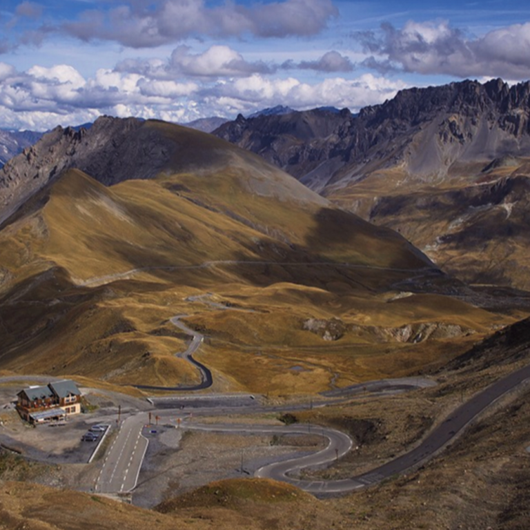
Col du Lautaret - 2056m
On the southern side, the Col du Lautaret serves as the gateway to the Galibier. Classified as a Category 1 climb, the tougher ascent from Bourg-d’Oisans gains 1,418 m over 34 km - you have to negotiate a number of tunnels though. From Briançon, however, it is a Category 2 climb. The pass marks the boundary between the Oisans valley and the Briançonnais region and is also regarded as the dividing line between the northern and southern French Alps.
The road connecting the two towns is busy, and while you will likely ride it when visiting the region, it is not a destination in its own right. That is a shame, as the surroundings are beautiful: a broad, open valley on the southern approach and a narrower, gorge-like valley from the west. At the summit, the Galibier massif towers over the landscape, and a botanical garden awaits those with the time and inclination to linger a little longer.
Col du Galibier from Valloire
Length: 17.5km
Altitude gain: 1213m
Max altitude: 2642 m
Average gradient: 6.9%
Max gradient: 11.9%
Col du Telegraphe from St Michel de Maurienne
Length: 11.9km
Altitude gain: 846m
Max altitude: 1567 m
Average gradient: 7.9%
Max gradient: 12%
Col du Lautaret from Bourg d'Oisans
Length: 33.7km
Altitude gain: 1418m
Max altitude: 2056 m
Average gradient: 4.2%
Max gradient: 10.5%
Route Tip: There is a route of epic proportions forming a circular ride that takes in the Galibier, Alpe d'Huez and the Col du Croix de Fer. This is a 185km ride covering 5500m climbing and maybe best done in two stages!