Cime de la Bonette - France
The Cime de la Bonette is a totally unique climb. It is long, high, very remote and has unpredictable weather. It is the highest "route" or through road in the Alps, but it is so much more. Together with the Colle del Nivolet, the Cime de la Bonette is in the league of most awesome roads ever.
The Cime de la Bonette is a curious extension of the Col de la Bonette, which itself reaches a pass height of 2,715 m. When the Col de l’Iseran was paved in the 1930s, it claimed the title of the highest paved pass road. Not to be outdone, local authorities constructed the loop road around the Cime de la Bonette between 1960 and 1961, climbing to just over 2,800 m in order to claim the distinction of the highest paved road and to enhance the area’s prestige. That title was later taken in 1982 by Austria’s Ötztaler Gletscherstrasse. However, as that road is a dead end, each can legitimately claim a different “highest” accolade: the Col de l’Iseran remains the highest paved pass road at 2,770 m, the Cime de la Bonette is the highest through road at 2,802 m, and the Ötztaler Gletscherstrasse is the highest paved road in the Alps at 2,830 m. Something for everyone.
Reducing the Cime de la Bonette to a simple contest of “highest” does not do it justice. This is a road that ventures deep into the mountains, far removed from civilisation. At higher altitude, the landscape becomes increasingly stark; above 2,000 m it turns rocky and desolate. The Caserne de Restefond stands as a solitary human outpost, long since reclaimed by the elements. It is also a reminder that this road was built for military purposes—something that becomes evident as it leads to virtually nowhere. While the Ubaye Valley can be lively, the Tinée Valley feels quiet and remote, and it is hard to imagine that, without military needs, such a high-altitude road would ever have been constructed, particularly given the often harsh weather conditions.
Cime de la Bonette – 2,803 m - Northern ascent from Jausiers
From Jausiers, the climb is 23.3 km long with 1,587 m of elevation gain—comparable to the Stelvio from Bormio, though around 2 km longer. Despite relatively moderate gradients, the relentless rise to over 2,800 m makes this a very demanding ascent. After leaving Jausiers, there are no further villages or mountain communities beyond Lans, and services are limited to a couple of cafés (it is worth checking in advance whether they are open).
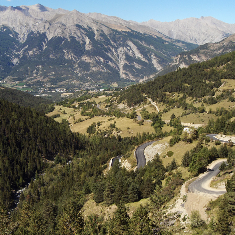
There are 27 switchbacks, which sounds impressive, but they are spread out over a long climb. The road never confronts you with a sudden “wall” of tightly packed hairpins; instead, it gradually penetrates deeper into the Mercantour National Park, taking you ever farther from civilisation. What truly sets this climb apart is that it rises above most of the surrounding peaks, allowing you to look down on the mountains rather than up at them—a rare and wonderful sensation, as if you are riding on top of the world.
There are three distinct sections to this ride:
Jausiers - 2000m altitude
From Jausiers, the first half of the ride—11 km in length with 740 m of elevation gain—takes you to around 2,000 m, roughly the tree line. Initially, the route follows a broad and varied valley. Right out of Jausiers, a series of switchbacks gets the climb underway. The village of Lans appears after about 5 km, and beyond this point the valley becomes quieter, narrowing after 7.5 km at a second set of switchbacks that negotiate a cliff face.
The road continues through greenery and scattered trees, though never through dense forest, and climbs at a steady gradient of between 5% and 8%. There are occasional sets of switchbacks, but the valley remains relatively open throughout. This is a truly delightful section of the ride. It is worth remembering that this is a long effort, and careful pacing is essential—especially given the altitude—if you want to reach the summit in good condition.
2000m altitude - Caserne Restefonde
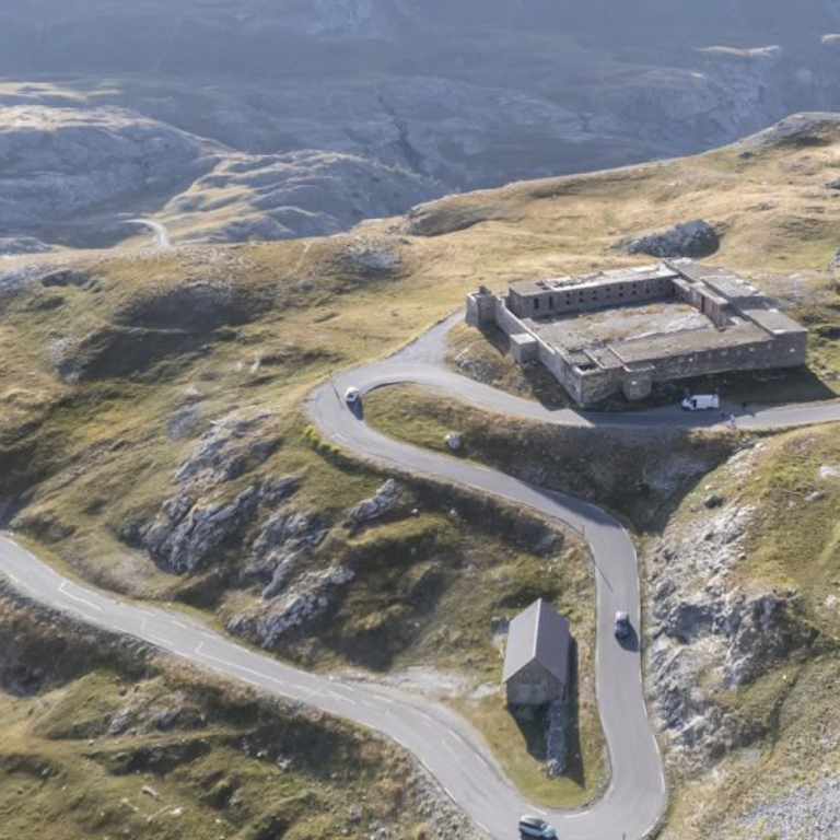
This middle section, covering around 8.4 km with 600 m of elevation gain (bringing the total to 19.4 km and 1,340 m of climbing at the Caserne de Restefond), opens into what feels like a vast alpine basin, where the true magic of the climb begins to unfold. For the first 3 km, green meadows dotted with occasional trees line the road as it continues deeper into the Mercantour National Park.
As the ascent progresses, the route becomes more twisting, and the lush meadows gradually give way to brown alpine grasses. In the final 3 km, stone and rock dominate the landscape as the road winds its way towards the Caserne de Restefond. Here, the road is fully exposed, rising to the level of the surrounding mountains and offering breathtaking views in every direction. The Caserne de Restefond itself is an eerie and unexpected landmark—a stark reminder that people once lived and worked in this harsh, rocky environment.
Caserne Restefonde - Cime de la Bonette
After the Caserne de Restefond, there are no further hairpins. The road sweeps gently to the right and, for the final 4 km, runs beneath the Sommet de Restefond toward the Bonette through what feels like a vast quarry. The gradients ease here, offering a brief opportunity to recover. To the right, across the valley, rises the Caire Brun at 2,823 m, while straight ahead lies the Bonette itself.
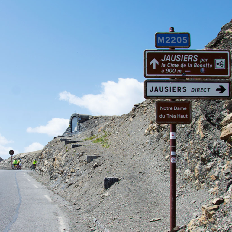
The Col de la Bonette is the next waypoint, but despite being the seventh-highest paved Alpine pass at 2,715 m, it feels little more than a junction, lacking the iconic plaques so typical of French high mountain passes. Perhaps the locals were disappointed that it falls 55 m short of the Col de l’Iseran.
From here, the road continues to the Cime: a fiendishly steep final 700 m that leads to the summit at 2,803 m, rewarded with a vast panorama over the Mercantour National Park. In total, the climb covers 23.7 km and gains 1,580 m of elevation—an unforgettable ascent.
Cime de la Bonnette from Jausiers
Length: 23.3km
Altitude gain: 1587m
Max altitude: 2803 m
Average gradient: 6.8%
Max gradient: 11.7%
Route Tip: If you want to go further than a single ascent from Jausiers, you can descent to Saint Etienne de Tinee and come back up the southern side. This is a total of 98km and 3200m elevation gain. If that is too much, descend to Bousieyas for refreshments before climbing back up on the upper slopes. Truly magical.