Col de l'Iseran - France
The Col de l'Iseran is the highest paved mountain pass in the Alps. It stands at 2,770m and tops the list of the very high mountain crossings.
It connects the French cycling heartlands of the Tarantaise and the Maurienne valleys and sits deep into the mountains nestled close to the Italian border. A ride from Bourg St Maurice to the north to Modane to the south is just shy of 100km.
Despite the superlatives of this pass in terms of mountain scenery, its very remote location and Tour de France fame, the Col de l'Iseran does not enjoy the same cult status than the Galibier or Alpe d'Huez. This is a real shame because this is a ride of superlatives - not so much in numbers but in the feeling the road exudes. The core climb is super, almost lovely, tougher from Bonneval from the south than from Val d'Isere but it is the surroundings of the high mountains around the pass and the pass road that drills deep into the mountain give the Col d'Iseran its specific character.
From Val d'Isere , the ski resort is visible for almost all of the northern ascent bar the last 3.5km and lifts go even past the pass height. By comparison, the south is wilder and more remote. The Haute Maurienne valley is a traditional working valley and has charming villages dotted along the way till the very end. Both sides are magnificient and should be high on anyones list to conquer.
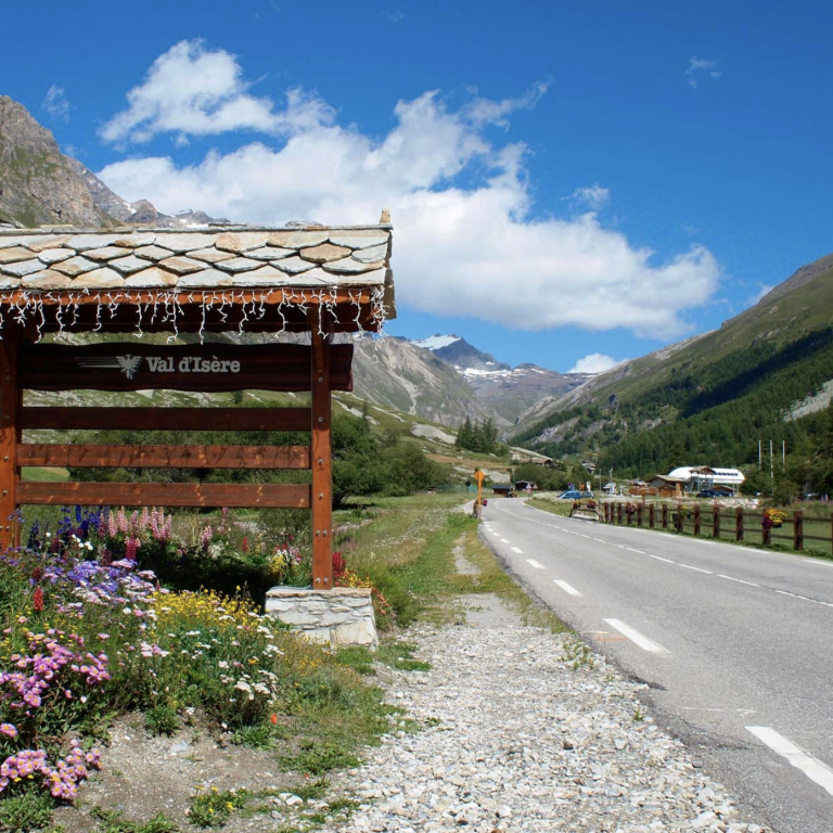
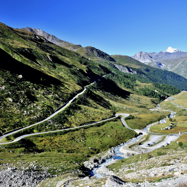
Northern ascend from Val d'Isere
If you start from Val d'Isere which is at an altitude of 1,830m, the climb is 16.7km long and covers 970m elevation gain with a manageable average gradient of 5.8%. Starting the climb from Val d'Isere, you can leave all the road stress behind and focus on what really matters - climbing an awesome pass road. There are three distinctive sections to this route, not too dissimilar to how the Galibier climb from Valloirer is structured.
Deep into the valley
The first 5 km from Val d’Isère, with an elevation gain of 230 m, follow a straight road alongside the Isère stream, deep into the Isère Valley, before the road turns sharply uphill to the right. If you were to hike deeper into the valley and cross the Col de la Loze, you would eventually reach Italy at Lago Serrù and the Colle del Nivolet.
The Col de l’Iseran is somewhat the sister pass of the Nivolet, sharing the same dramatic and beautiful surroundings. But back to the Isère Valley we are riding through.
Once you leave Le Fornet—the last outpost of Val d’Isère—behind, the valley immediately becomes quieter. It is a relatively narrow valley, with the road running above the Isère stream. Halfway along, the ramps and switchbacks of the climb up the hillside ahead come into view on the right, giving a first glimpse of what lies ahead.
Up through lovely switchbacks
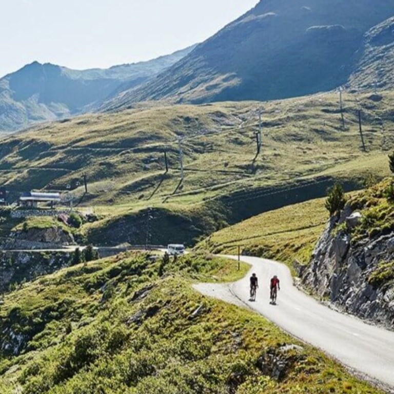
For the next section, up to an altitude of 2,520 m, the road climbs in a series of switchbacks up the mountainside, high above the Isère Valley. Val d’Isère remains constantly in view, and the route feels as though it is climbing upwards rather than moving forwards.
The road gains 480 m over 7.8 km, meaning the gradients are never extreme. The higher you climb, the more impressive the views become, both over the valley below and towards the surrounding mountains, many of which rise above 3,000 m.
This stretch of road passes directly through the ski area and is also used as a piste in winter. There are several cable cars and ski lift installations along the way, but if you look beyond them, this remains a spectacular road.
There are seven switchbacks on this section, along with several very long ramps, some stretching up to 3 km. As you look down towards Val d’Isère below, the climb feels less remote until the road turns right for the final 3.5 km, opening onto a vast high-altitude plateau towards the pass.
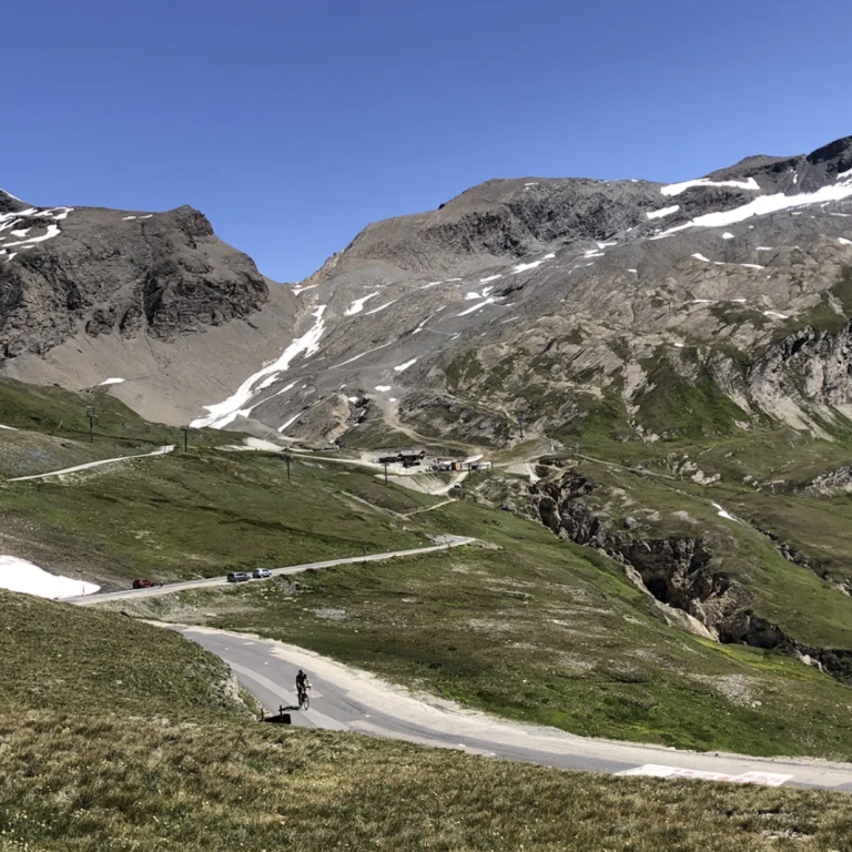
Deep into the mountain
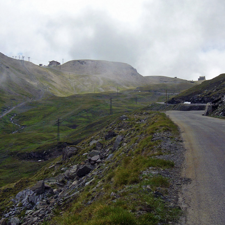
The final 3.5 km, with 260 m of elevation gain, crosses a vast open expanse between the Signal de l’Iseran (3,237 m) on the left and the Pointe des Lessières (3,043 m) on the right. The road runs straight ahead, hugging the right side of this high-altitude plateau.
Without the ski infrastructure, this would be one of the most remote sections of the French Alps. Bourg-Saint-Maurice lies 50 km to the north of the pass, while Lanslebourg in the Haute Maurienne Valley is 33 km to the south. To the east lies the Gran Paradiso National Park in Italy, and to the west there is nothing but mountains rising to almost 4,000 m.
The gradient increases slightly here but remains below 10%, apart from the final switchbacks near the summit. At this altitude, the main challenge is not the gradient but the thin air, as the Col de l’Iseran is the highest paved mountain pass in the Alps—higher than the Stelvio.
The manageable gradients allow you to fully appreciate the scale and solitude of the landscape, making this one of the most majestic climbs in the Alps.
Southern ascend from Bonneval-sur-Arc
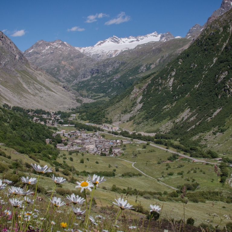
The climb from Bonneval-sur-Arc is 13.4 km long, with 980 m of elevation gain, and, with an average gradient of 7.3%, is significantly tougher than the northern side. Bonneval is a delightful Savoyard village at the end of the Haute Maurienne Valley, seemingly in the middle of nowhere. It is also one of the most picturesque villages in the French Alps.
Climbing the Col de l’Iseran from the south feels much wilder than the northern ascent, as there are no ski stations, and the route opens up exceptional views of the mountains surrounding Mont d’Ambin and Mont Albaron, which rises to 3,638 m on the southern side of the Haute Maurienne Valley near the Italian border.
The climb becomes progressively tougher, wilder, and more dramatic the higher you ascend. It steadily tightens the screw and, like most great climbs, can be divided into several distinct sections.
Leaving the Haute Maurienne Valley behind
The first 5.3 km from Bonneval-sur-Arc, gaining 350 m in elevation, rise high above the village and deep into the Lenta Valley. With an average gradient of 6.6%, this is the easiest section of the climb. Bonneval-sur-Arc itself sits at around 1,800 m, and after a sharp left-hand turn, the road climbs high above the village in two long ramps before turning inward into the Lenta Valley towards the Iseran Pass.
The route then continues steadily along the valley until a bridge over the Lenta River signals the beginning of a new section of this magnificent climb.
Riding into the dramatic Lenta valley
For the next section, up to an altitude of 2,532 m, the road climbs 410 m over 5.6 km, and the average gradient increases to 7.3%. The climb tightens the screw with every pedal stroke.
This section is truly magical. Through three switchbacks, the route rises high above the Lenta Valley, opening up unreal views of the surrounding mountains and the valley far below, which forms a deep, cliff-like gorge. The road then clings ever more dramatically to the mountainside until it reaches the Pont de la Neige, where the route finally meets the floor of the Lenta Valley once again.
Final push through incredible mountains
The final 2.4 km, gaining 220 m in elevation, increase the average gradient further to 9.2%. At the Pont de la Neige, the views back over the southern Haute Maurienne mountains disappear, and your focus shifts entirely to the final stretch of climbing ahead. The gradient becomes brutal.
The valley below appears increasingly rugged and churned up, while great cliffs emerge in the distance as the road climbs relentlessly in a straight line for 1.7 km. Infamously Julian Alaphilippe lost the yellow jersey in the 2019 TdF on this stretch. The final switchback begins to open up views of the surrounding mountains and the Vanoise National Park to the west. Finally, the Notre-Dame de Toute Prudence chapel comes into view, signalling your arrival at this magnificent pass.
Col de l'Iseran
From Val d'Isere
Length: 16.3km
Altitude gain: 930m
Max altitude: 2,770m
Average gradient: 5.7%
Max gradient: 15%
From Bonneval-sur-Arc
Length: 13.4km
Altitude gain: 980m
Max altitude: 2,770m
Average gradient: 7.3%
Max gradient: 15%
Route tip: Although the recognised starting point from the north is in Bourg St Maurice, starting from Val d'Isere is highly recommended. The 31km from Bourg St Maurice to Val d'Isere can be busy with heavy traffic and trucks plus a number of tight tunnels thrown in which give a cyclist nowhere to go. Also, starting form Val d'Isere makes a double ascent doable. A round trip down the southern side to Bonneval sur Arc is around 60km and 1950m climbing. The official starting point of the climb from the south is Lanslebourg and it includes a warm up climb of the Col de la Madeleine.