Multi Day Rides
Experiencing the mountains a different way by keeping on riding
There are great routes and challenges in riding the Alps and beyond and I put together a few itineraries that I find particularly interesting.
Exiting bike packing tours detailed here
The long routes are between 8-10 days riding, cover between 600 to 850km and between 15,000 to 22,000 m elevation gain:
Mountain bonanza from Thonon les Bains on Lake Geneva to Alpe d'Huez and return
Riding through the heartland of the Northern and Southern French Alps
Riding through Italy (Aosta Valley & Piedmont) and Switzerland
Crossing Austria West to East from Bregenz on Lake Constance to Graz
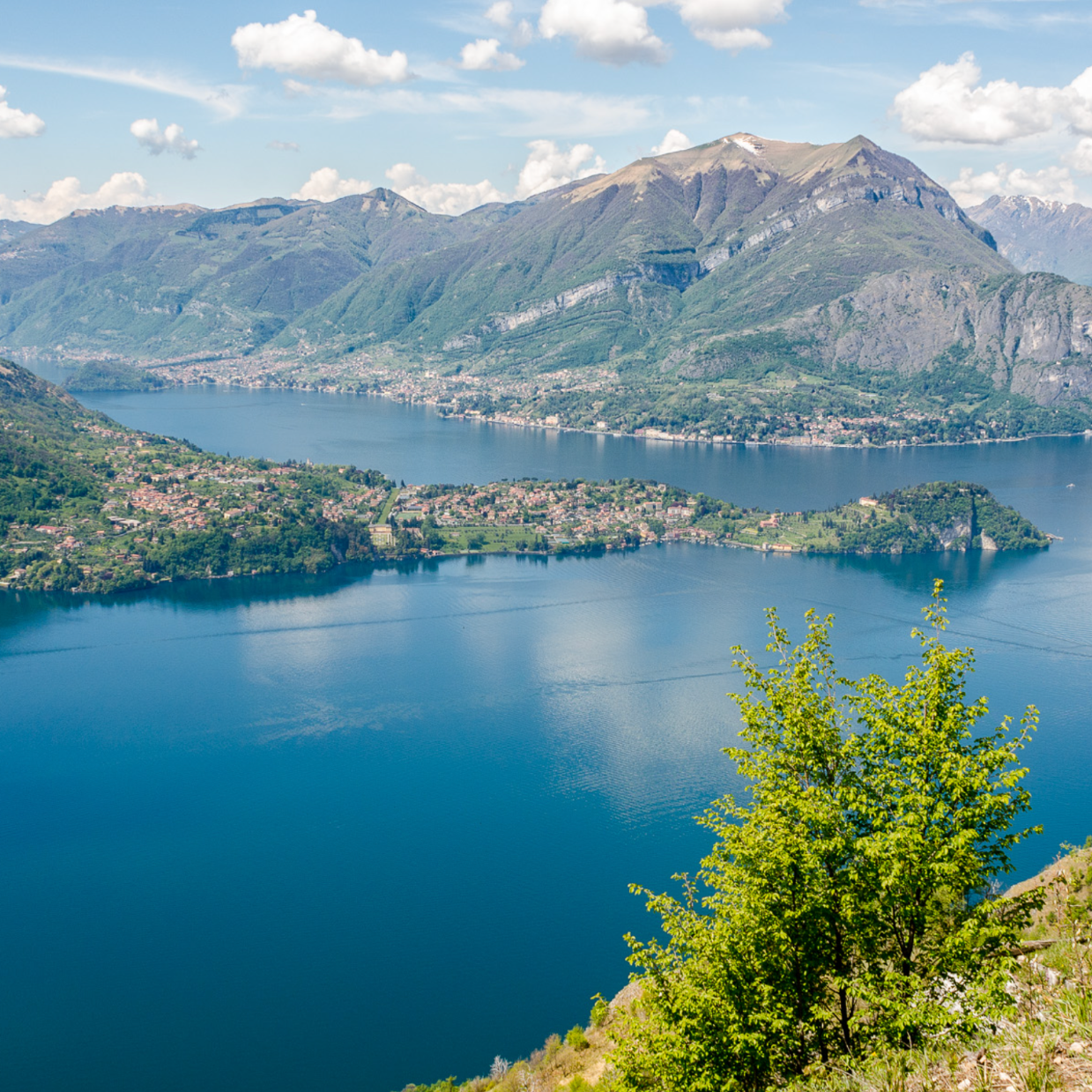
Exploring Italy from Varenna on Lake Como to Innsbruck in Austria
The medium routes cover 5 - 7 days riding of between 500 to 600 km and 12,000 - 13,500 m elevation gain:
Crossing the Eastern Italian Alps - East to West
Crossing the Alps North to South from Munich to Conegliano
Crossing the Alps North to South from Munich to Bergamo
Exploring Austria, Italy & Switzerland from Lake Constance
Exploring the Italian Alto Adige / Südtirol from Innsbruck
Exploring Italy (Lombardy) and Switzerland from Bergamo
Short routes: I also included a short ride of of 2 days including 4 climb cycling loop in Switzerland:
Furka, Grimsel, Nufenen & Sankt Gotthard passes
Read on for further detail.

A ride starting and ending in Lake Geneva and taking in Frances highest mountains and passes plus a detour to Italy and Switzerland to climb the Grand St Bernard, the most historic of alpine crossings. In total this ride covers 835km, spans 17 climbs with around 22,000m climbing. I would plan for 10 days.

Following the Route des Grandes Alpes from Lake Geneva taking in the lower passes of Col du Feu, the Plain Joux, the Collombiers, the Col des Aravis and the Col des Saises.
It enters the high mountains at the Cormet de Roselend followed by the Col d'Iseran which is the highest road pass in the Alps. The high point of this leg though is the Telegraph/Galibier. It reaches Alpe d'Huez via a scenic road above the Romanche valley before hitting the famous Alpe d'Huez switchbacks.
I suggest a rest day in Alpe d'Huez. In addition to the large climbs, there are smaller climbs en-route which brings this leg of the ride to 424km and 12,000m climbing over 5 days riding.
Route tip: One famous Col is chasing the next on this route. We suggest to take a taxi from Bourg St Maurice to Val d'Isere as the traffic is horrendous and these are just "dead" km.
Also, the route to Alpe d'Huez climbs above the Romanche valley which is a nice side road but you will miss the first few switchbacks of the famed Alpe d'Huez climb.

The return leg is equally challenging and climbs the Col de la Croix de Fer/Glandon and the Col de la Madeleine in the queen stage. This could also be split into two day's riding.
The Col du Tra livens up the valley ride form Moutier to Bourg St Maurice. From here, the route goes off to Italy via the Col du Petit St Bernard and then into the Aosta Valley via the Colle St Carlo. The following ascent to the Colle de Grand St Bernard takes a route away from traffic on the right side of the valley.
The ride is topped off by a climb to the Lac de Morgins from Switzerland and down to Thonon les Baines.
This leg of the ride comes to 411km and 9,800m climbing over 4/5 days riding.
Route tip: This is an intense route crossing into Italy and then Switzerland. We propose to stay the last night on the St Bernard pass at the historic hospice to honour the historic importance of this pass. Due to its business, we propose to climb on the right side of the valley which is super scenic and with little traffic.
The valley floor in the Aosta valley will be busy though but that can't really be avoided.
Epic Cycling Climbs Route 2: Ride through the heartland of the Northern and Southern French Alps - 8 day ride
This is a 725km route with 17,350m elevation gain, possibly 8 days of riding. The ride starts in Val d'Isere (taxi ride from Le Bourg Saint Maurice to save you from a busy 32 km ride on a main road) and ends in the La Chambre in the Maurienne valley. In between the route covers 12 climbs in the heartland of the Northern and Southern French Alps.
This is an incredible ride, defined by the sheer variety of mountain environments it traverses. It includes three of the highest passes in France, as well as iconic climbs from both the Northern and Southern Alps, with the Col de la Croix de Fer and the Col de la Couillole standing out in particular. Beyond steep ascents steeped in Tour de France heritage and folklore, the route features fast descents, quiet and often deserted roads, and a striking contrast of landscapes—ranging from desolate, barren high mountains to lush valleys and narrow gorges. Along the way, charming mountain towns and villages offer warm local hospitality. Above all, the ride delivers some of the most spectacular scenery France has to offer.
Day 1 (105km, 2,140m climbing): The journey begins in Val d’Isère, with the first day ending in Valloire after crossing the Col de l’Iseran, the highest paved road pass in the Alps, followed by the Col du Télégraphe.
Day 2 (105km , 2,620m climbing): Two bucket list climbs are on the programme today. The day starts early with the ascent of the legendary Col du Galibier, then descends to Briançon before tackling the Col d’Izoard, famed for its mythical landscape. The day concludes in Guillestre.
Day 3 (91km, 2,780m climbing) : A demanding day is in store today with the Col du Vars as a warm-up climb, followed after lunch by the magnificent Cime de la Bonnette. This stage is tough both in distance and elevation gain, the reward is crossing the highest through road in the Alps and the magical scenery of the Mercantour National Park. The day finishes in Saint-Étienne-de-Tinée halfway down the Tinee valley.
Day 4 (84km, 1,850m climbing): The route continues through the warmer, southern Tinée Valley, climbing the Col de la Couillole, with the dramatic Vionène River gorge as a highlight. It descends to Guillaume via Valberg and ends in Saint Martin d'Entraunes on the lower slopes of the Col de la Cayolle.
Day 5 (92km, 1,890m climbing): The route turns north again, reaching Lac de Serre-Ponçon via the beautiful Col de la Cayolle and the Ubaye Valley. A last climb of the day to Le Sauze-du-Lac, high above the lake provides great views.
Day 6 (90km 1,940m climbing): This stage features valley riding along the Durance Valley, punctuated by short climbs on quiet side roads, and ends on the slopes of the Col du Lautaret. This is a persistent uphill effort passing towns of Embrun and Briancon.
Day 7 (87km, 2,140m climbing): The penultimate stage completes the ascent of the Lautaret, followed by a scenic route above the Romanche Valley and a climb through the famous switchbacks of Alpe d’Huez. The stage ends around Allemond in the d'Oisans valley after a crazy descent.
Day 8 (75km, 1,970m climbing): Finally, on the last day, the route returns to the Maurienne Valley via the legendary Col de la Croix de Fer, and descending to La Chambre via the Col du Glandon, with an additional bonus climb to the Lacets de Montvernier to bring the journey to a memorable close.
Climbs en route: Col de l'Iseran, Col du Telegraph, Col du Galibier, Col d'Izoard, Col du Vars, Cime de la Bonnette, Col de la Couillole, Col de la Cayolle, Col du Lautaret, Alpe d'Huez, Col de la Croix de Fer and Lacets des Montverniers.
The start at Bourg Saint Maurice and the end point of this route at La Chambre can be accessed by train which is a bonus. Alternatively, you could extend a further day to ride back to Bourg Saint Maurice via the Col de la Madeleine and the Tarentaise valley.
This route through Italy starts in Conegliano just north of Venice and ends in Sondrio, north of Milan. This is a 500km route climbing just around 12,100 meters over 11 mountains. You can look at the route here an Komoot.
The first part of the ride in through the Venetian Dolomites climbing Passo San Boldo, Franche and Duran. Passo San Boldo is an engineering masterpiece, climbing a tight gorge with the switchbacks largely in rickety tunnels.This is followed by the Dolomites climbing heartland with passes Staulanza, Giau, Falzarego, Pordoi and Costalunga. The mountain here make this a really magical part of the ride. Wonderfully flowing roads and massive scenery await.
The next passage covers around 100km from Bolzano, via Merano to the foot of the Stelvio climb and is purely in the valley, along rivers and largely on cycle paths.
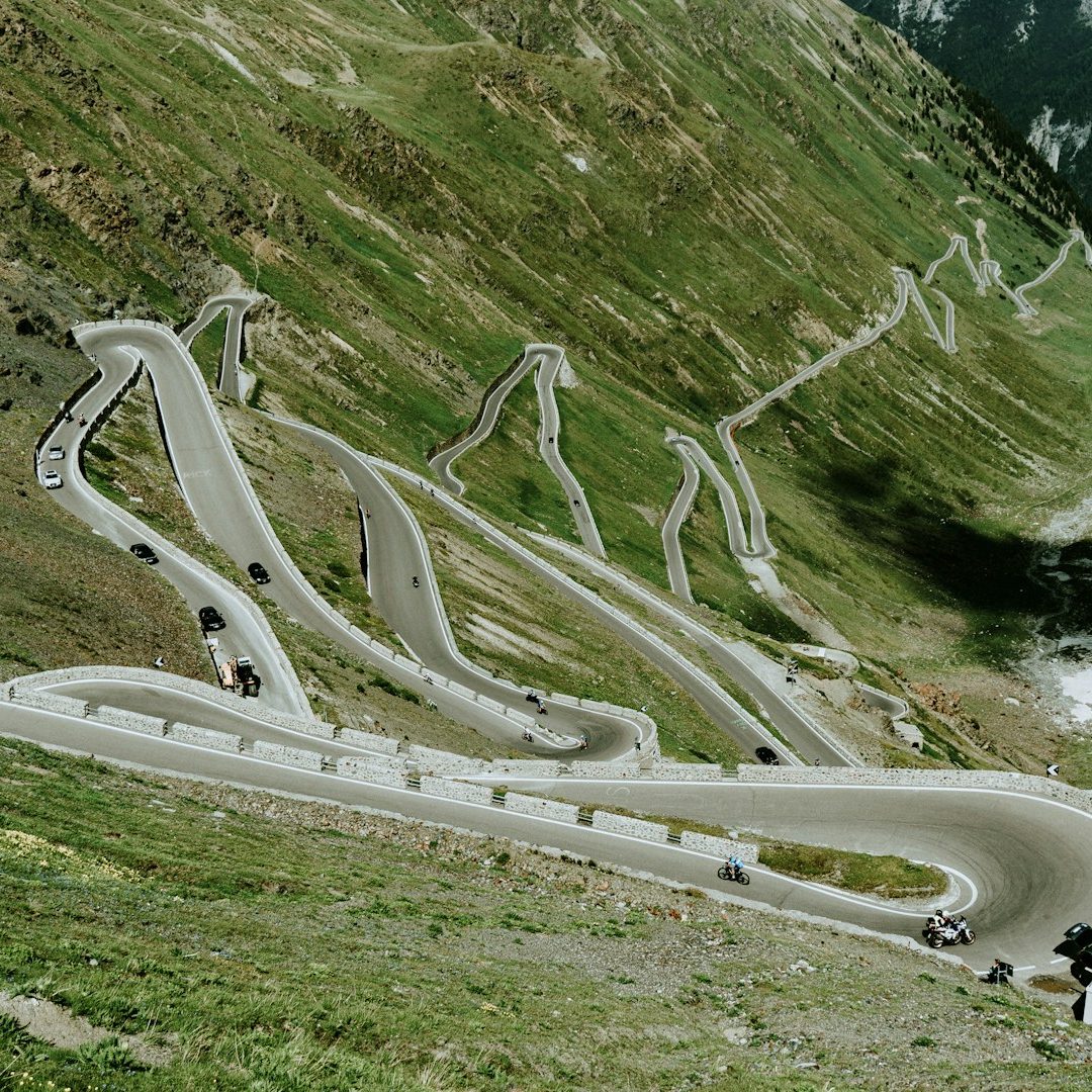
The last section is the tough threesome of the Stelvio, Gavia and Mortirolo before ending at Sondrio. Each of them is a tough test for any cyclist but they are mythical in cycling terms and epic is not enough to describe this section. It is in many ways the very heart of Italian alpine cycling.
There is transport to and from the starting and end point by train. If you want to extend the ride, the climb to Passo San Marco and the descent all the way to Bergamo via the Brembo valley and its cycle way would be an option.
Epic Cycling Climbs Route 4: Ride through Italy (Aosta Valley & Piedmont) and Switzerland - 10 day ride
This is a 852km route with 20,360m elevation gain, possibly 10 days of riding. The ride starts in Bourg Saint Maurice in France and weaves its way to Lindau on Lake Constance in Germany, through Italy climbing high passes in the Aosta Valley and the many climbs in the Piedmontese foothills before navigating through Switzerland. The route spends four days in the Aosta Valley including climbs to the Small and Grand St Bernard passes. It takes three days riding in the lower lying foothills in Piedmonts and the Italian lakes. The final three days are crossing Switzerland climbing the Sankt Gotthard and Oberalp passes and the spring of the Rhine River before following it to Lake Constance. The stages are spaced for around 2,000m climbing per day and not longer than 130km which means that stops can be remote and adjustments might need to be made based on accomodation. This ride shows off the best of the Western Alps including cobbled stretches and a little bit of gravel.
Day 1 (66km, 1,940m climbing): The journey begins in Bourg Saint Maurice in France from where it climbs the incredible Col de Petit St Bernard, heads into Italy via the Colle de St Carlo and finishes in the valley at Avise.
Day 2 (55km , 2,100m climbing): The day starts with a crunchy 500m climb to St Nicholas high above the Aosta valley. From there it continues 2/3 on the eastern side up the mountain to the Great St Bernard pass till the mountain village of Saint Remy.
Day 3 (97km, 2,310m climbing) : From there, an early morning ascent of the remainder climb to the Great St Bernard pass awaits followed by a long descent to the valley. The route stays above the valley floor and climbs the Colle del Panthaleone which also features in the Giro before descending to Chatillon.
Day 4 (76km, 1,990m climbing): The last day in the Aosta valley climbing the Col de Joux and then descending through the main valley to Piedmont where the day ends in Donato after a short climb.
Day 5 (70km, 1,870m climbing): The route turns onto small roads and through a more constant up and down along the Piedmontese foothills. It climbs two passes including the Bocchetto di Sessera pass, through rickety tunnels, past religious sanctuaries and always with great vistas. A fab day which mixes riding with local culture.
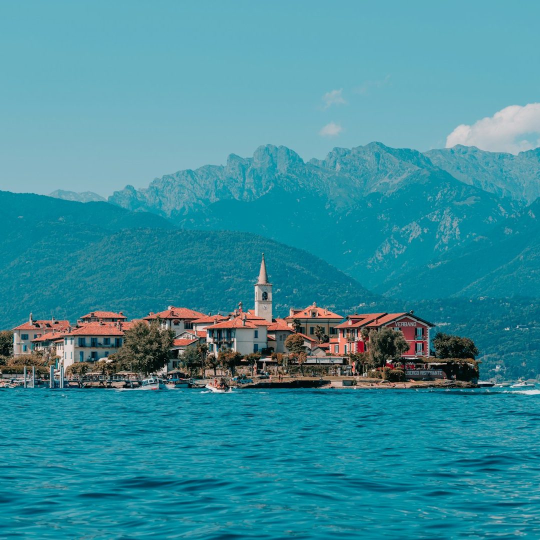
Day 6 (85km 2,150m climbing): This stage reaches the upper Italian lakes. It climbs the Alpe Noveis before reaching Lago di Orta. After circling around the northern end of the lake, the day comes to an end at the lower slopes of the Mottarone at Armeno. This is a very up and down ride with a number of climbs.
Day 7 (78km, 2,350m climbing): This is a demanding day at Lago Maggiore. There are two climbs on the agenda: Mottarone and the Monte Morissolo. Both have steep gradients, are hot and sweaty but offer unrivalled views over the lakes. The day ends in Cannero Riviera on Lago Maggiore. There might even be time for dip in the lake to cool off.
Day 8 (105km, 1,860m climbing): A transitional stage between the lakes and the Sankt Gotthard pass and a time to recover the legs a bit from the previous day. The ride continues along Lago Maggiore to Bellinzona and up the Ticino valley with a climb before reaching Aiollo at the foot of the Sankt Gotthard. From Chironico onwards, the ride starts to climb significantly and includes a 5km section of hard gradients before reaching Aiollo.
Day 9 (99km, 2,350m climbing): This is probably the hardest day riding of the trip. The route climbs up the Old Tremolo Road to the Sankt Gotthard pass which is largely on cobbles and which will take more energy than a smooth road. This is a bucket list climb though and after a medium long descent to Hospental, the route climbs the Oberalp pass, also the spring of the Rhine. There is a 35km downhill before the road climbs to Obersaxen and ends further down the valley in Valendas.
Day 10 (123km, 1,470m climbing): The last day of riding has a special surprise in store. After Tamins, the route tackles the Kunkelspass which is only partly paved and has sections of hard packed gravel and famous tunnels. As it is also quite steep, you might have to push your bike for 1-2 km but it is traffic free and truly enchanting. The downhill takes us on rickey roads to Bad Raganz and then via the Luzisteigpass to the Rhine valley and along the river on cycle paths to Lake Constance where the route ends in Lindau. If you want to shorten the end of this stage, there are train stations all along the Rhine valley in Austria. The first one being Feldkirch, lobbing as much as 40km off this stage.
The start at Bourg Saint Maurice and the end point of this route at Lindau can be reached by train which is a bonus. For a shorter ride, the route can be stopped after day 6 at Stresa on Lago Maggiore which is also connected by train to Switzerland and France. Given that there are quite a variety of different road surfaces involed on this ride, the tire choice will be crucial.
You can look up the route on Komoot here.
West - East ride starting at the western end of Austria in Bregenz and ending in Graz. The route covers 822km, 13 climbs and 18,500m elevation gain. The terrain is super varied and covers the highest mountains but also mountain roads at lower altitude in a more gentle setting. It covers cycling along valleys and crazy steep climbs. It passes pretty villages and shows off Austria from its best side. I would plan for 8 riding and 1 rest days.
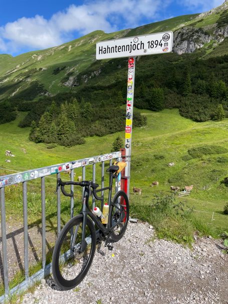
The ride starts off in Bregenz climbing the Pfänder with a view over Lake Constance before rolling through the Bregenzerwald over the Lorena and Hochtannbergpass to the bottom of the Hahntennjoch.
This is a serious climb like many of the climbs on this route. Past Imst and the Inntal, the route climbs the Kühtai, via the Silzer Sattel, which is the first pass over 2000m before meandering past Innsbruck and the Inntal valley to the Zillertal. The Silzer Sattle is optional as the gradient is quite intense and the Kühtai can also be climbed from Ötz village instead.
In the Zillertal another mad climb awaits, the Zillertaler Höhenstrasse to Melchboden. This used to be a track connecting the hill side villages and it seems that apart from tarmacking, it is still a mad mountain track. The route then reaches the Grossglocker via the Gerlospass.
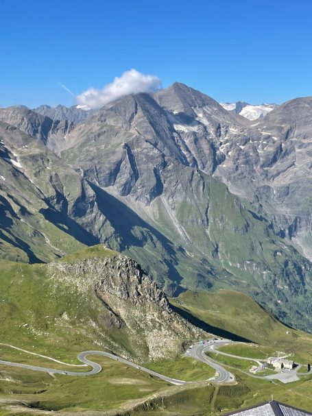
The Grossglockner is the high point of the route and contains two climbs. First, the road climbs 1800m up the Edelweissspitze at 2571m which is just awesome. The second climb is along the road from the Edelweissspitze to the Franz-Josephs-Höhe at 2400m with fab views of the Grossglockner.
After a long descent, the mountain roads gradually become lower in altitude and the Eisenthalhöhe and the Schietzlerscharte on the Nockalmstrasse at around 2040m is the last of the high passes over 2000m. The Nockalmstrasse is a wonderful road throughout.
The rest of the route to Graz covers the Hochrindl and Klippiztörle passes both just over 1600m. This is followed by the Packsattel at 1200 before the last 50km go up and down to Graz.
There is a direct train back from Graz to Bregenz, slow but it takes your bike.
Epic Cycling Climbs Route 6 and 7: Crossing the Alps North to South from Munich to Upper Italy
Munich is a great starting point to cross the Alps north to south. These routes cover Germany, Austria and Italy and ending in Conegliao (Venice) and Bergamo (Milan) respectively. The route to Milan is more dramatic and climbs higher passes, whereas the route to Venice meanders more across lower lying passes with the exception of the Grossglockner Hochalpenstrasse.

Starting from Munich, this route sets out towards Conegliano near Venice. It covers 567km, 12,000m climbing over 11 passes.
With the exception of the Grossglockner, these passes are all at lower levels and the route has therefore a more constant up and down character, especially in the Venetian Dolomites where there are great roads to explore like the Valle del Mis and the Passo San Boldo.
The northern run in through the Bavarian hills is more gentle which is great to get your riding legs going. I suggest 6 days riding and 1 rest day.
Route tip: There is some intense riding in the middle section of this route around the Grossglockner and then into Italy and a rest day in between the big days might be a nice way to break it up. Oberdrauburg sits in the middle of those heavy days and is a wee town that provides quiet and chill time.

Another nice bike packing adventure takes you north to south from Munich to Bergamo.
I put together a route suggestion here with 590km in length and just over 12,000m climbing. This route includes dramatic passes with great cycling folklore as it traverses the Kühtai, Timmelsjoch, the Stelvio.
The northern run in through the Bavarian hills is more gentle which is great to get your riding legs going. I suggest 6 days riding and 1 rest day.
Route tip: The best place for a rest day is Merano which is historic spa town between Timmelsjoch and Stelvio.
There are hot baths, good food, and a cable car ride to Merano 2000 for great mountain views and hiking. What more to ask for on a rest day.
This is a 585km route with 12,260m elevation gain, possibly 6 days of riding. The ride starts in the town of Lindau on Lake Constance in Germany and covers five climbs in Austria, three in Italy and two in Switzerland. The highpoint of the ride is the mighty Stelvio pass, ridden from the northern side from Pad am Stilfserjoch. You can look at the route here an Komoot.
This is an incredibly varied ride due to the variety of mountain environments. The ride starts at Lake Constance and the lower lying mountains of the Bregenzerwald, followed by the Alps of the Tyrol. The Italian side includes the Stelvio and Foscano passes where the ride stays for large part here above 2000m altitude. Switzerland offers fabulous Bernina and Albula pass, gorges, some gravel, valleys and towns and a run out through ever lower mountains ending with a flat section along the river Rhine and back to Lindau on Lake Constance. Lindau and Lake Constance are ideal to relax after a long ride. There is some more info here.
What marks this ride out is that it covers different countries with different roads and paths, there are different mountains ranges with very different environments covering famous and hidden climbs and there are valleys and gorges. As this ride is partly in Switzerland, the route also crosses mad train lines.
There is transport to Lindau by train from Munich and Zurich airports. If you want to skip Lake Constance and start further down the Rhine valley, Rankweil is a good alternative starting point which also has a train connection.
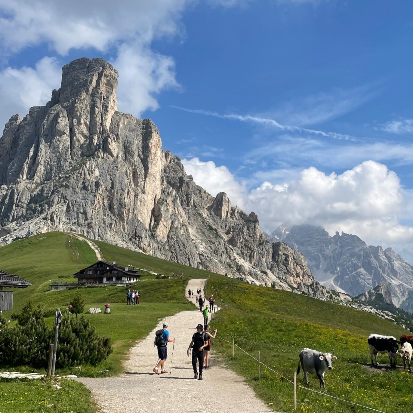
Multi day ride to cross the Italian Alps form Innsbruck across Alto Adige in Italy and back to Innsbruck, see the route here: Multi day route in Alto Adige from Innsbruck, 540km, 13,440m elevation gain across 9 climbs and passes and is broken down into six riding days with a suggested rest day in Wolkenstein. This is a great ride across the Alto Adige province and covers passes in the western Dolomites to the east of the Eisacktal valley and the passes and climbs of the Adige and Passeirer valleys. Without a rest day, this route is 6 days riding and requires five nights’ accommodation.
The ride starts off in Innsbruck which is very well connected via planes, trains and automobiles! So a great jump off point. The route goes up to the Brenner pass to Sterzing in Italy which is a shorter ride day to get the legs going. Likely to be busy though. Then the climbing starts in earnest with the Penserjoch the first climb on the agenda, the route then drops down to Bozen and then via shorter climb from the Eisack valley to Kastelruth via the Schlern mountain.
Kastelruth is the start for the next day will be rough with 2900m climbing up the Würzjoch through the lovely Villnöß valley followed the road to Alta Badia and the Grödnerjoch to Wolkenstein and always through the most breathtaking mountain scenery. A rest day would be in order.
The ride continues with another long but less tough climbing day with the ride up the Sellajoch as the main climb. Down to Canazei past the Sella mountain and through the Val di Fassa to the Karerpass. We take a right turn around the Rosengarten mountain and towards the Nigerpass only 1km down the road. The road continued to Seis and a scenic and magical ride into the Seiser Alm past the Schlern and overlooked by the Sasso Piato and Lungo mountains.
The following day, the route leaves the Dolomites and transitions to the Passeirer valley via Bozen/Bolzano and a sharp 1000m climb up to Mölten, then high above the Adige valley to Merano and more down to earth along the Adige river to St Leonhard. The last day takes in the Jufenpass then down to Sterzing and ultimately back to Innsbruck.


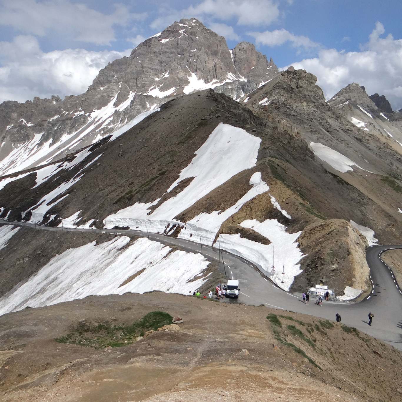
Epic Cycling Climbs Route 10: Two-Day Alpine Cycling Loop: Furka, Grimsel, Nufenen & Sankt Gotthard
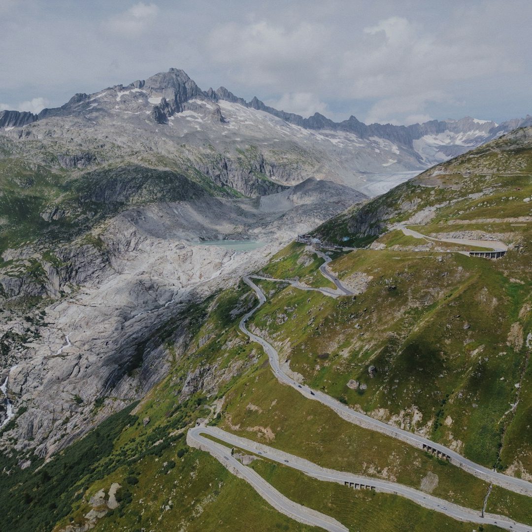
This spectacular 132 km route with 4,200 m of climbing showcases one of Switzerland’s most concentrated clusters of higAlpine passes. With four major climbs above 2,000 m and scenery that borders on the surreal, it’s an unforgettable journey through the heart of the Central Alps. The Furka, Grimsel, Nufenen, and Sankt Gotthard passes sit within a remarkably compact area just south of the Rhône Glacier, whose icy tongue once reached the road near the historic Belvedere Hotel as recent as the 1990s. The hotel now stands closed — a quiet marker of the glacier’s retreat and a reminder of the region’s changing landscape. Just over 150 years ago, the Rhone Glacier reached nearly all the way to Gletsch, the start of the Grimsel Pass road.
While some riders tackle Furka, Nufenen, and Sankt Gotthard in a single day, adding the Grimsel Pass and spreading the effort over two days creates a more relaxed itinerary and allows time to truly appreciate the dramatic surroundings.
Day One: Hospental → Furka Pass → Grimsel Pass → Ulrichen (72km, 2,100m climbing)
The journey begins in the small village of Hospental at the base of the Sankt Gotthard. The road climbs steadily through the valley toward the Furka Pass, passing the iconic viewpoint made famous in the James Bond film Goldfinger. Just above it sits the Belvedere Hotel, perched dramatically on a switchback and used to offer views of the Rhône Glacier.
From the top of the Furka, the panorama is classic high Alps: ice fields, sheer cliffs, and the distinctive grey granite that defines the region. The ascent of the Grimsel Pass is visible from here, adding a sense of anticipation for what lies ahead.
After descending the western side of the Furka, the route turns sharply right and begins a 400 m climb to the Grimsel Pass via a tight series of switchbacks. Instead of returning the same way, the route continues down till the old Grimsel road — partly cobbled and wonderfully atmospheric — dropping to around 1,500 m. The scenery here is exceptional and worth lingering over.
The day concludes with a climb back to the pass and a final descent into Ulrichen, a quiet Alpine village ideal for an overnight stop.
Day Two: Ulrichen → Nufenen Pass → Airolo → Sankt Gotthard → Hospental (60km, 2,100m climbing)
The second day begins with the long, steady ascent of the Nufenen Pass. Climbing roughly 1,130 m over 13.7 km to 2,482 m, it’s a demanding start and one of Switzerland’s highest paved passes. Though less dramatic than its neighbours, it offers wide‑open views and a satisfying sense of scale.
From the summit, the descent leads toward Airolo and the start of the legendary Tremola Road — a true bucket‑list climb. This historic cobbled route snakes up the mountain in a series of beautifully engineered hairpins, offering one of the most memorable cycling experiences in the Alps. Traffic is minimal, gradients are more challenging on the cobbles, and the atmosphere is unmistakably old‑world Alpine. Reaching the Sankt Gotthard Pass at 2,109 m after nearly 930 m of climbing feels like a genuine achievement.
The final descent back to Hospental can be taken via the smooth, modern main road or partly down the cobbled Old Gotthard Road, depending on weather conditions and equipment.
You can check out the route on Komoot here.
Epic Cycling Climbs Route 11: Eight day ride from Varenna on Lake Como in Italy to Innsbruck in Austria.
This 559 km route, with 15,400 metres of climbing, starts in Varenna on Lake Como and takes in the lower-altitude climbs and passes of the Bergamo Alps in Lombardy before transitioning via Trento into Alto Adige / Südtirol and continuing over the Penser Joch to Innsbruck in Austria.
In total, the route includes fourteen climbs and passes and is quite demanding, as lower-altitude passes often tend to be steeper than their higher-altitude counterparts. With an average of around 2,000 metres of climbing per day — and considering the steep gradients and numerous tempting places to stop — this itinerary is best suited to an eight-day ride. However, as the daily stages are relatively moderate in terms of distance and elevation gain, it would be possible to shorten the trip to seven days, averaging approximately 2,200 metres of climbing per day. The stand out climbs are the Passo Crocedomini and the Penser Joch.
Stage 1 (65km, 2,120m elevation gain): The route begins in Varenna on Lake Como, which can be reached by train. You may choose to stay on Lake Como before the ride and cycle up to the Madonna del Ghisallo from Bellagio, then take a boat across the lake to Varenna. The first stage includes two climbs — Passo Agueglio and Culmine San Pietro — and offers stunning views over the lake before heading inland toward the Bergamo Alps. The day concludes in the village of Vedeseta.
Stage 2 (70km, 1,840m elevation gain): This is a more relaxed day of riding, featuring rolling terrain with steady climbs and descents. The route begins in the Vedeseta Valley and ascends the Zambla Pass via the Taleggio Gorge, passing through delightful scenery along the way. The day ends in the village of Dorga.
Stage 3 (80km, 2,550m elevation gain): This is a tougher day, beginning with the completion of the ascent to the Presolana Pass before continuing along a rolling route to the climb of Passo Crocedomini. The Passo Crocedomini is demanding, with 1,650 metres of climbing and sections that reach double-digit gradients. The day concludes with a 20 km descent into Bagolino.
Stage 4 (97km, 2,040m elevation gain): The day begins in Bagolino and heads north towards Trento. There are four climbs on this stage, with the Sella di Andalo as the highest point at 1,134 metres. The route passes the beautiful Lake Molveno, which is well worth a stop to admire its setting. Towards the end of the day, there is a sharp ascent of around 300 metres to Sporminore, partly on gravel. The stage finishes in the village of Cunevo.
Stage 5 (76km, 1,940m elevation gain): This stage starts in Cunevo and finishes in Terlan in the Adige Valley, just west of Bozen. It includes two main climbs: the Gampenpass (1,517 m, with 557 m of climbing) and the Brezer Joch (1,399 m, with 492 m of climbing). The route also passes Lago di Santa Giustina and features rolling terrain, with continual ups and downs throughout the day.
Stage 6 (34km, 1,340m elevation gain): This stage runs from Terlan to Bozen, a distance of only 14 km along the valley cycle path. However, we take the longer and more challenging route via the Mölten climb, high above the Adige Valley. Although this is effectively a half-day of riding, the climb is fiendishly difficult, with 1,200 metres of elevation gain and gradients reaching up to 18%. Bozen is a beautiful town and well worth spending the afternoon exploring and recovering.
Stage 7 (57km, 2,010m climbing): This stage runs from Bozen to Pens. It is not long, but it is steep. We take a detour via Klobenstein, which is a superb 1,100-metre climb straight out of Bozen, before joining the Sarntal Valley and riding on to Pens, located halfway up the Penser Joch pass.This stage can be lengthened by including an ascent to the lovely Lake Vadurna which makes this stage 78km long and climbs 2,560m.
Stage 8 (79km, 1,520m elevation gain): The final stage runs from Pens to Innsbruck and is a day to savour. It begins with the remaining 700 metres of climbing to the Penser Joch pass, a superb mountain road, before descending to the charming town of Sterzing. After a break in Sterzing, the route tackles a short climb to the historic Brenner Pass, followed by a descent along the old road into Innsbruck.
As an alternative finish, you could return to Bozen from Sterzing via the Eisack Valley. Although this valley can be busy, over 40 km of the route are on cycle paths, and there are several historic towns worth stopping in. This variation would extend stage 8 to 104 km with 1,240 metres of climbing.
Varenna and Innsbruck can be reached by train and returning from Innsbruck to upper Italy by train is reasonably straight forward but requires four changes and most of the day to reach Varenna (avoid the Frecciarossa fast train as that does not take an assembled bike). If you return to Bozen, transport will become a touch easier.
Epic Cycling Climbs Route 12: Six-Day Cycling Loop from Bergamo through Italy and Switzerland
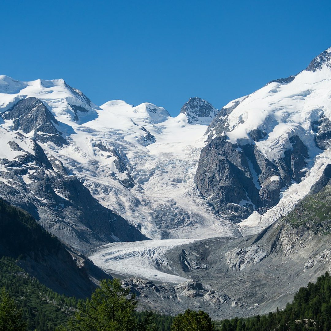
This is a wonderful six-day cycling route through the mountains of Italy and Switzerland, starting and ending in Bergamo. The route combines the best of two different worlds: the lower-lying Bergamo Alps, with their steep climbs and quaint villages, and the dramatic high passes in Switzerland around Piz Bernina and the canton of Graubünden.
Bergamo can be reached easily by plane or train and is an excellent starting point for an Alpine adventure. Overall, the route covers 537 km with 12,780 m of elevation gain over six days, crossing 10 mountain passes, five of which are over 2,000 m. In Switzerland, the route climbs the Albula and Bernina passes and visits the Avers Valley, which seems to have stood still in time. In Italy, highlights include the Passo San Marco and the Splügen Pass, as well as several climbs frequently featured in the Tour of Lombardy.
If the final stage feels too demanding, the last climb on the approach to Bergamo—Passo di Ganda, made famous by the Tour of Lombardy—is optional, reducing the total elevation gain by around 680 m.
A truly wonderful ride, with stages averaging around 2,000 m of climbing, allowing plenty of time to appreciate the dramatic surroundings.
Stage 1 - 69km, 1,640m elevation gain: The route begins in Bergamo city entre and ends in Mezzoldo on the lower slopes of the San Marco pass. The stage is shorter to ease into the ride. After leaving Bergamo, the route follows the Brembo river on side roads till we reach the climb to Dossena which is roughly 10 km long and cover 650m elevation gain, a taste of things to come. Dossena is visited frequently by the Tour of Lombardy and offers spectacular views over the Bergamo alps. After a sharp descent back into the Brembo valley, the climb to the San Marco pass starts which is broken up by stopping for the day in Mezzoldo.
Stage 2 - 96km, 2,260m elevation gain (ride total 165 km, 3,900 m elevation gain): From Mezzodolo, stage two ends in Campodolcino on the approach to the Splügen Pass. First though, the last 1,000 m climbing to the San Marco pass is on the agenda. This a fabulous pass, connecting the lower lying Bergamo Alps with the high mountains of the Valetelina. After a long descend to Morbenio, the route stays in the valley for around 40 km, skirting the top end of Lago di Como and then turning towards the Splügen Pass along the Mera river. The day ends at Campodolcino after the frist 800m climbing towards the Splügen Pass.
Stage 3 - 63km, 2,165m elevation gain (ride total 225km, 6,065m elevation gain): This is a magical stage as we cross into Switzerland, climb the rest of the Splügen Pass and end the ride by riding to the end of the Avers valley to Juf which at 2,126 m altitude is the highest year round inhabited alpine village. But first, the Splügen Pass covers a tight gorge and treats the rider to endless hairpins either side of the pass, a truly mesmerising road. After the descend, we take road 13 along the valley which criss crosses the motorway 13 till the turnoff to the Avers valley. Before the road was built, the Avers valley was long cut off by a hard to navigate gorge and has maintained it end of the world remoteness and charm and offers a truly unique way to experience the mountains.
Stage 4 - 95km, 2,155m elevation gain (ride total 320km, 8,220m elevation gain): This is another wonderful stage as the route includes the Albula Pass from Tiefencastel which climbs 1,360m over 22.5 km. First the route descends back through the magical Avers valley to the Hinterrhein valley where we follow the road 13 past the wonderful Viamala Gorge. At Thusis, the route turn right onto the Albula road via the Soliser Viaduct, Albula and Tiefencastel towards the Albula pass. This is a long and hard climb with up to 12% gradient. It is criss crossed by the quaint Albula railway, which goes all the way to the top at 2,360 m altitude and crosses the road on fabulous viaducts. The climb passes the Bergün gorge and after a short descend, the day ends in La Punt Chamuses at the foot of the Albula pass.
Stage 5 - 100km, 1,630m elevation gain (ride total 420 km, 9,850 m elevation gain): Day 5 has less elevation gain as we circumnavigate the mighty Piz Bernina which stands at 4,049 m altitude and the Bernina range dominates the landscape. Coming from La Punt Chamuses, the ascent to the Bernina pass is with 578 m elevation gain relatively short and is ending at the Lago Bianco, with the railway line always in view. The descend to Tirano in Italy is long, around 33 km, dropping 1,900 m from 2,325 m to 441 m. This is a good road offering a fast descend. The main climb of the day is the Aprica pass from Tirano, which climbs 780m over 11.5 km before the road descends for the last 25 km to Malonno at the foot of the Vivione pass. To even stage 5 and 6 out, you can carry on for 7.5 km and 360 m elevation gain to Paisco where there is a hostel. This would bring the total of the day to 108 km and 1,990 m elevation gain and shortens the next day.
Stage 6 - 116km, 2,890m elevation gain (ride total 537 km, 12,780 m elevation gain): This stage is either very hard or less hard. If the very hard version is too much, the last climb can be skipped which saves 680 m of climbing and around 10 km of riding and goes right to Bergamo through the main valley (106 km, 2,200 m elevation gain). First up is the Vivione pass, which sits on a remote and heavily forested road. It is no slouch, climbing 1,369 m over 19.8 km with gradients up to 14% and to an altitude of 1,827 m. This is followed by the Passo della Presolana, a 550 m climb over 8 km. If you had enough climbing at this point, the road goes straight to Bergamo along the Serio river. To complete the full route, carry on to Passo di Ganda which is a further 680 m climbing over 9.6 km to make this a very demanding day. Alternatively, if you start from Paisco, the stage is 109 km long and climbs 2,530 m.
La Routes des Grandes Alpes
Route
The most famous route to cross the Apls is the Route de Grandes Alpes in France from Lake Geneva to Nice. This route takes in around 16 passes, 750km and 18,000 elevation gain and this web-site sets out many of the route options.
There are variations and the route can be designed with more or less climbing, but all the highest and famous passes can be included: Col d’Iseran, Col de Galiber and the Cime de la Bonette. Some take detours like the Komoot route here does to Alpe d'Huez and ends in Monaco, some offer a gravel route and some replace the Cime de la Bonnet with the Col d'Allos or the col de la Cayolle.
Regardless of what route you take, traversing the French Alps north to south (or in reverse) is one of the greatest trips available in the Alps. This route on Komoot can get you started. For more inspiration, check out Mike Cotty's non stop ride form Evian to Nice on the Col Collective.
Routes outside the Alps
Traversing the Pyrenees
Traversing the Pyrenees is another famous route. Check out this route on Komoot. This version is about 800km long and about 19,000 climbing but length and elevation gain is depending on your route. This route takes in all the famous passes of the Pyrenees and takes 12 days; like all routes it can be adapted to your preferences.
Bike holidays will likely involve travelling with your precious carbon unless you rent a bike and these travel tips might be helpful.