Switzerland
With the largest number for peaks over 4,000m in the Alps, cycling in Switzerland can only be described as "Epic".
What makes cycling in CH so epic?
The Swiss mountains are high — very high. With 48 peaks rising above 4,000 metres, Switzerland has more than three times as many as France, while its 437 summits above 3,000 metres are almost double Austria’s total. Yet these extraordinary heights do not necessarily translate into the highest cycling passes, many of which lie in France, Italy and Austria. What Switzerland offers instead is an abundance of epic Alpine scenery, vast glaciers and routes that venture deep into the high mountains. Sadly, many of these glaciers are retreating rapidly, adding a sense of urgency to experiencing this remarkable landscape.
Switzerland’s appeal goes well beyond altitude. The historic Tremola Road to the Sankt Gotthard Pass delivers one of the Alps’ great cobbled climbs, while the extraordinary circular route over the Col du Sanetsch can include a cable-car descent operated by a hydroelectric company. In the heart of the country, spectacular loops link three major passes in a single ride, while the Grosse Scheidegg offers a high-altitude cycling experience on a road largely reserved for buses and bicycles.
Some of the most memorable rides lead not to mountain passes but to remote reservoirs. Roads climb towards the turquoise waters of Lac de Mauvoisin, the imposing Mattmark Reservoir and the spectacular Lago di Naret, each surrounded by dramatic mountain scenery. Switzerland’s remarkable railway network adds another dimension, with trains crossing high passes such as the Bernina and Oberalp, opening up routes that would otherwise be difficult to combine.
There is, however, one less appealing aspect to cycling in Switzerland: the prices are almost as high as the mountains. Accommodation, food and transport can make a cycling holiday expensive, so careful planning is essential. Choose your base wisely, book ahead and make good use of the rail network, and you can enjoy some of the most extraordinary cycling in Europe without having to remortgage your house afterwards.
Mountainous Heart
The centre of the Swiss Alps is not only home to an extraordinary cluster of 3,000 - 4,000m mountains, it is also the source of two of Europes great rivers - Rhine and Rhone and of a very high density of mountain passes.
Urner Alps - South Central Switzerland
Stretching from the Oberalp Pass in the east towards Leukerbad in the west, the Urner Alps encompass a magnificent landscape of towering 3,000-metre peaks, glaciers and deep Alpine valleys. This is a region where some of Switzerland’s greatest mountain ranges converge, and where road cycling becomes an exploration of both spectacular scenery and the forces that have shaped Europe. The range sits at the confluence of a number of cantons: Valais, Uri, Bern and Ticino.
The focus for cycling is the eastern part of this mountain world, where two of Europe’s great rivers begin their journeys (the western part of this range is in Wallis and does not have any mountain passes). The Rhône Glacier gives rise to the Rhône, which flows westwards towards Lake Geneva and eventually the Mediterranean, while the Oberalp Pass lies close to the source of the Rhine, which travels northwards to the North Sea. To the south, the historic Sankt Gotthard Pass provides one of the great crossings between northern and southern Europe, while the landscape extends towards the lakes and valleys of central Switzerland, including Lake Brienz to the north.
The mountains are defined by their contrasts: immense rocky summits, retreating glaciers, turquoise reservoirs and narrow valleys carved by ice and water. Few Alpine regions bring these elements together so dramatically. Andermatt sits at the heart of this network, a natural crossroads from which some of Switzerland’s most celebrated mountain passes can be explored (see Travel Destinations).
The Furka, Grimsel, Susten, Oberalp, Nufenen and Sankt Gotthard passes each offer a different perspective on the high Alps. The Furka sweeps past the Rhône Glacier, the Grimsel crosses a stark landscape of granite and mountain reservoirs, and the Susten climbs through spectacular rocky terrain. The Sankt Gotthard offers something altogether different: the historic Tremola Road, with its cobbled hairpins winding up the mountainside. Further north, the Grosse Scheidegg provides another remarkable high-mountain crossing.
For road cyclists, this concentration of passes makes the region exceptional. Long ascents, exhilarating descents and roads that repeatedly cross the 2,000-metre mark can be combined into demanding loops or explored over several days from Andermatt. Yet the appeal goes beyond the physical challenge. These roads reveal the scale of the mountains, the immense power of glaciers and rivers, and the ingenuity required to build routes through such formidable terrain.
The Sankt Gotthard, in particular, has played a pivotal role in European history. For centuries, merchants, pilgrims and travellers crossed here between the German-speaking lands and Italy. The old Tremola road stands as a lasting monument to that endeavour, its cobbled switchbacks recalling an age when crossing the Alps demanded extraordinary effort and engineering skill.
Few places in the Alps bring together the grandeur of the mountains, their importance as a source of Europe’s water and the history of human passage so vividly. In the Urner Alps, road cycling becomes more than a succession of climbs: it is a journey through the natural forces, historic routes and enduring ambition that have shaped the heart of Switzerland.
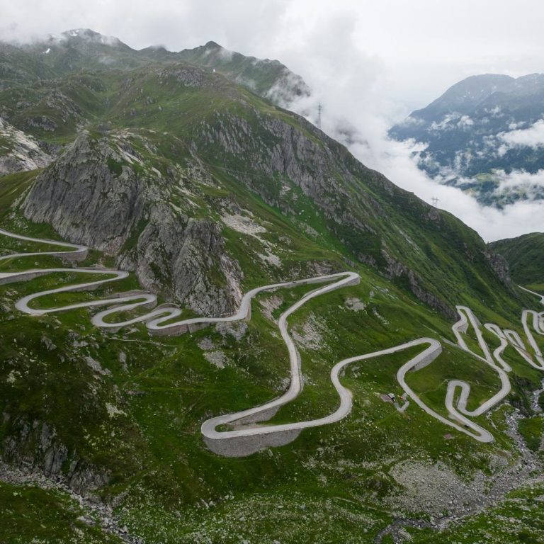
The pass via the old Tremola road is famous for its cobbles and spectacular switch backs.
From Airolo, the climb is 13.2km long and climbs 923m with an average gradient of 7%. This is a very unique road.
For a very long ride, the circular ride from Andermatt taking in the Furkapass, Nufenen and St Gotthard Pass is a 105km ride climbing 3,187m.
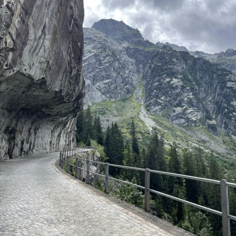
The Grimsel Pass is dramatic and alien, featuring a stark granite-hewn landscape, massive hydroelectric dams like Spitallamm, and bright blue reservoirs like Grimselsee and Totensee that give it an otherworldly, industrial-majestic feel.
From Innertkirchen, the Grimsel Pass is 26km long and climbs 1,534m to an altitude of 2,162m. Part of the old road are still in use which is worth taking.
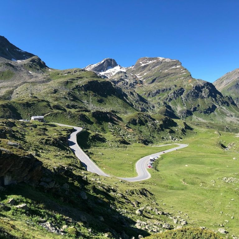
The Grosse Scheidegg is with 1,966m just under the 2,000m mark but opens up views on the Eiger, Scheidegg and other great mountains. The road is partly traffic free which makes it the highest cycle path I know of. Both sides of the climb are equally mesmerising. From Meringen the climb is 16.1km long and climbs 1,270m with an average gradient of 7.9%, the Grindelwald side is shorter but steeper.
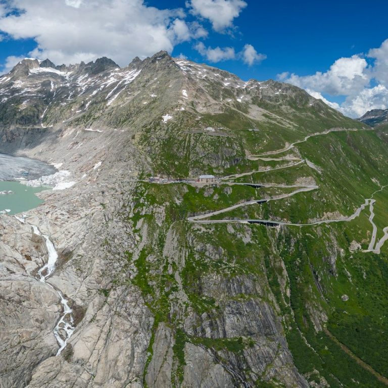
The Furka Pass reaches an elevation of 2,429 meters and connects Gletsch in Valais with Realp in Uri, and is known for its stunning views and as a filming location for the James Bond movie "Goldfinger".
From Realp it is 12.2km long and climbs 891m. For more elevation gain, you can also start further out from Andermatt.
Other significant passes in the Swiss mountain hearland
2,478 m, Nufenenpass / Passo della Novena, Switzerland, pass connecting Ulrichen and Airolo: From Ulrichen, climbing roughly 1,130 m over 13.7 km to 2,482 m, it’s a demanding climb and one of Switzerland’s highest paved passes. Though less dramatic than its neighbours, it offers wide‑open views and a satisfying sense of scale.
2,223 m, Sustenpass, Switzerland, pass connecting Innertkirchen (Canton of Bern) and Wassen (Canton of Uri): Gradients are steady and manageable, allowing you to settle into a rhythm while the scenery grows ever more spectacular. Above the tree line, glaciers and jagged peaks come into view, and the landscape takes on a raw, high-mountain intensity. Tunnels and sweeping hairpins add to the sense of scale. Reaching the summit feels cinematic — surrounded by ice, rock, and vast skies — before a thrilling, flowing descent carries you back down through one of Switzerland’s most beautiful alpine corridors.
2,164 m, Grimselpass, Switzerland, pass connecting Innertkirchen (Bern) and Gletsch (Valais): The climb rises through forests before breaking into a stark, high-alpine landscape of bare granite, reservoirs, and sweeping hairpins. The gradients are steady and testing rather than extreme, but the scale of the surroundings gives the ascent real weight. Reaching the summit feels elemental and expansive — as if you’ve climbed into a world of rock, water, and sky — followed by a long, exhilarating descent through one of the Alps’ most striking landscapes.
2,044 m, Oberalp Pass, Switzerland, pass road connecting Göscheren and Disentis - 16km, 943m elevation gain
1,980 m, Lukmanier Pass, Switzerland, pass road connecting Disentis and Blenio - 17km, 912m elevation gain
Valais / Wallis
Home of the 4,000+ meter mountain peaks
The Valais (German: Wallis) is one of Switzerland’s most distinctive regions, shaped by its dramatic Alpine geography, historic routes into Italy and the coexistence of French- and German-speaking communities. For centuries, the Rhône Valley has provided a natural corridor through the mountains, connecting settlements and trade routes. Today, the same landscape draws visitors to its historic passes, traditional villages, vineyards, glaciers and spectacular mountain scenery.
The Valais is also the heartland of Switzerland’s highest mountains. Forty-one of the country’s 48 peaks above 4,000 metres lie in the canton, concentrated along the Italian border around Zermatt and Saas-Fee, where the Matterhorn and Monte Rosa dominate the skyline. This formidable mountain barrier is framed by two historic crossings: the Simplon Pass to the east and the Great Saint Bernard Pass to the west. Between them, the highest peaks are largely inaccessible by road, and exploring their foothills means following long side valleys towards places such as Zermatt or the spectacular Mattmark reservoir in the Saas Valley.
For road cyclists, the Valais offers an extraordinary variety of terrain. The south-western mountains are generally lower and more accessible, with climbs towards remote reservoirs and the passes around Verbier and the Great Saint Bernard. Further north, the Col du Sanetsch is a standout ride. Its quiet road climbs through a secluded valley, passes over the col and continues to Lac de Sanetsch, a scenic mountain reservoir. From here, a cable car operated by the hydropower company descends to Gsteig in the upper Saane Valley.
Across the canton, long Alpine ascents rise from the sunny vineyards of the Rhône Valley into rugged mountain scenery. Riders can tackle high passes, explore remote side valleys or combine several climbs into demanding loops, although choosing quieter roads helps avoid traffic on the main valley route.
Martigny makes an excellent base for exploring the Valais (see Travel Destinations), with access to the Great Saint Bernard, Col de la Forclaz, Col des Planches and routes towards the Sanetsch region. Further east, the Rhône Valley leads towards Brig, the Simplon Pass and the high valleys of Saas and Zermatt. With its immense peaks, secluded roads and historic crossings, the Valais offers some of the most varied and spectacular cycling in the Swiss Alps. The Furka, Nufenen and Grimsel passes are technically in Valais but really belong in the Swiss mountainous heart described above.
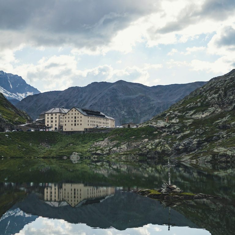
The Col du Grand-Saint-Bernard at 2,473m is a 41km long, rewarding climb, gaining 1,983m in elevation with the best scenery saved for the final kilometres. The approach through the lower valley can be busy (climb via the Lac Champex instead), and the tunnel sections require particular care, so bring front and rear lights. Beyond the tunnel, the road steepens and the landscape opens into magnificent high-Alpine panoramas around the summit lake. Start early to enjoy quieter roads, and take time to visit the hospice and café before descending back to Martigny or into Italy for a spectacular ride towards Aosta.
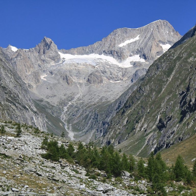
Tough, gorgeous and remote road to the Col du Sanetsch (2,247m) and then a further 4 km to the Lac de Sanetsch (2034m) - a reservoir lake - where the road ends. From Sion the climb is 25.7km long and covers 1,818m altitude gain. It is a tough and irregular SHC category climb which leads to a remote valley. There are no ski stations, no villages and no services with the exception of a mountain inn halfway up and at the end. A ride up can be extended by taking a cable car down to the Saarne Valley and returning via the Rhone valley.
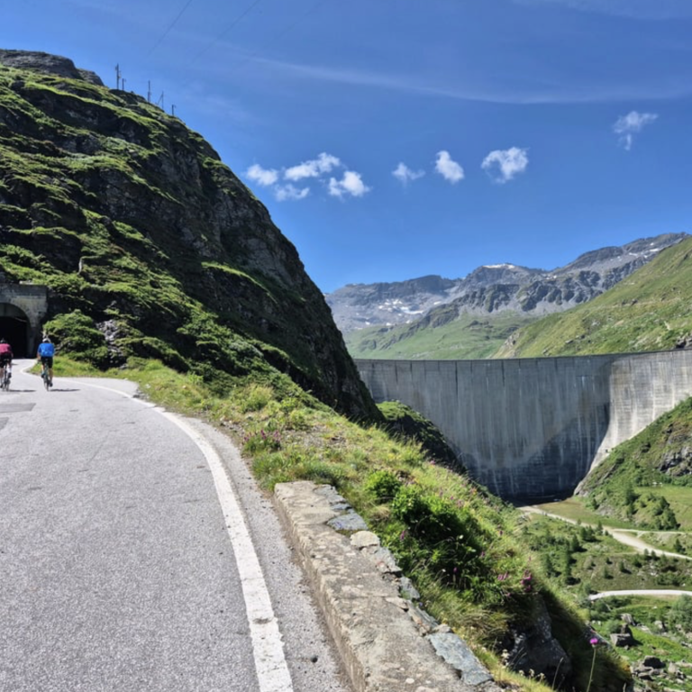
The climb to the Moiry Dam at 2,260m is a spectacular but demanding ride, gaining around 1,770m over 27km from Sierre. The road is in excellent condition, but the gradients become increasingly punishing beyond Grimentz, with a brutally steep final ramp to the dam. The effort is richly rewarded by the extraordinary turquoise lake and dramatic mountain scenery. Continue beyond the dam along the narrow road for even better views of the lake and nearby glacier. Bring lights for the dark, sometimes wet tunnels.
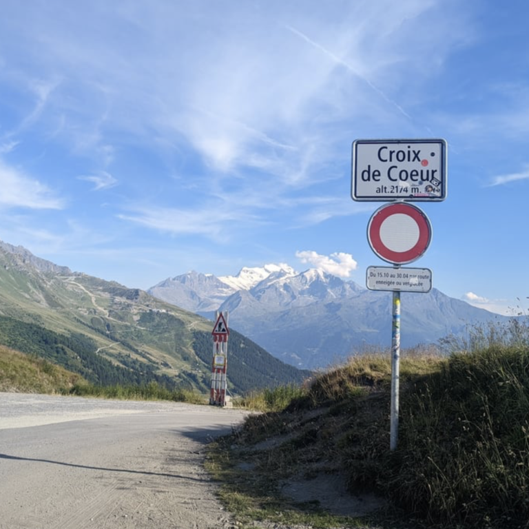
The climb to the Croix de Cœur at 2,171m from Riddes is a long, demanding ascent over 21km and rising 1,689m, with relentless ramps leading through La Tzoumaz before the road narrows and climbs into quieter, more rugged terrain above the treeline. Several tunnels make a rear light essential and there is rougher surface and hard packed gravel near the summit. The reward is spectacular: sweeping views over Verbier towards the Grand Combin and the distant Mont Blanc massif.
Other significant passes and climbs in Valais/Wallis
2,203 m, Mattmarksee reservoir, Switzerland, dead end from Stalden - 27km, 1,460m elevation gain
2,048 m, Moosalp, Switzerland, pass road connecting Visp and Stalden - 18km, 1,400m elevation gain
2,120 m, Arolla, Switzerland, dead end from Sion - 38km, 1,704m elevation gain
1,967 m, Lac d'Emosson, Switzerland, dead end from Route de Forclaz - 11km, 903m elevation gain
1,963 m, Mauvoisin reservoir, Switzerland, dead end from Sembrancher - 25km, 1,283m elevation gain
1,786 m, Val de Ferret, Switzerland, dead end from Orsieres - 16km, 911m elevation gain
1,685 m, Col du Lein, Switzerland, pass road connecting Saxon and Etiez - 14km, 1,216m elevation gain
1,617 m, Zermatt, Switzerland, dead end from Stalden - 30km, 951m elevation gain
1,527 m, Col de la Forclaz, Switzerland, pass road connecting Martigny and Argentiere (France) - 13km, 1,026m elevation gain
1,497 m, Col du Champex, Switzerland, pass road connecting Les Valettes and Orsieres - 11km, 860m elevation gain
1,411 m, Col des Planches, Switzerland, pass road connecting Martigny and Sembrancher - 10.3km, 920m elevation gain
1,380 m, Torgon, Switzerland, dead end from Vionnaz - 15km, 995m elevation gain
1,373 m, Lac de Morgins, Switzerland, pass road connecting Monthey (CH) and Abondance (France) - 24km 1,176m elevation gain
Further magnificent Swiss pass roads
Further magnificent Swiss pass roads and climbs
2,501 m, Umbrailpass / Giogo di Santa Maria / Pass Umbrail, Switzerland / Italy, pass connecting Santa Maria Val Müstair and Bormio: Virtually unknown, this is the "highest" pass road in Switzerland. Not too long ago, this pass was not even paved and it is eternally eclipsed by the mighty Stelvio next door. It need not hide though as the ascend is fabulous.
2,327 m, Berninapass / Passo del Bernina, Switzerland, pass, Celerina and Tirano - The Passo del Bernina from Tirano is a long climb of two distinct halves. The initial ascent through the warm, often busy valley is relatively gentle, with a welcome flatter section beside Lake Poschiavo at Miralago. Beyond Poschiavo, the road becomes considerably steeper, with sustained gradients of 8–12% leading towards the junction for Forcola di Livigno, followed by a final push to the pass. The excellent road surface and increasingly spectacular high-Alpine scenery make the effort worthwhile, with Lago Bianco and views towards the Bernina massif at the summit. Watch for traffic, particularly coaches, and take care when crossing the Bernina Express railway tracks in the villages.
2,311 m, Albulapass (Pass d'Alvra), Switzerland, pass connecting Tiefencastel, via Bergün and La Punt (Engadin): There’s a quiet grandeur to the pass — helped by relatively light traffic and the sight of the Rhaetian Railway threading through the valley below. Reaching the summit feels calm and satisfying rather than dramatic: a high, windswept plateau where the air is thin, the light is sharp, and the mountains seem to stretch endlessly in every direction.
2,311 m, Lago del Narèt, Switzerland, dead end from Fusio in Ticino: The road rises high above the Val Bavona in the Italian-speaking canton of Ticino, climbing steadily on a narrow ribbon of tarmac that twists through forests before opening into stark, rocky alpine terrain. The final kilometres feel almost lunar — granite, water, and sky dominating the landscape — until the turquoise reservoir appears, framed by austere peaks.
2,284 m, Julierpass (Pass da Güglia), Switzerland, pass connecting Silvaplana and Tiefencastel: The road is wide and impeccably engineered, climbing in long, sweeping curves that make you feel exposed to the vast alpine landscape. The gradients are steady rather than savage, but the altitude and openness give the ascent a serious, high-mountain character. Above the tree line, the terrain becomes stark and mineral — rock, water, and sky dominating the view — with the road carving a clear line toward the summit.
2,114 m, Splügenpass / Passo dello Spluga, Switzerland / Italy, pass connecting Splügen (Graubünden) and Chiavenna (Lombardy) - The Splügen Pass from Splügen is a relatively short, steady climb, with a succession of spectacular hairpins that give the upper section a distinctly Stelvio-like feel. The gradients are generally manageable, and the road winds through beautiful Alpine scenery, becoming particularly impressive above the treeline. Traffic can be busy during peak season, and roadworks may affect the hairpins, so check conditions before setting off. At the summit, the weather can change quickly, making the descent chilly in mist or cold conditions.
2,065 m, Passo del San Bernardino, Switzerland, pass connecting Thusis and Bellinzona: The Passo del San Bernadino is a very busy transit route and picking a route that does not use the main pass road is very important. If you stay away from the traffic, this is a fantastic climb, well worth it.
2,006 m, Simplonpass / Passo del Sempione, Switzerland, pass connecting Brig, Switzerland and Domodossola, Piedmont: The Simplonpass is included here due to its historic significance as a key pass road over the centuries. It is busy though.